فائل:Mohammad adil-Rashidun-empire-at-its-peak-close.PNG
ایں پیشگی ݙکھالے دا حجم:٨٠٠ × ٣٨٨ پکسلز ٻیاں قرارداداں: ٣٢٠ × ١٥٥ پکسلز | ٦٤٠ × ٣١٠ پکسلز | ١,١٩٦ × ٥٨٠ پکسلز۔
اصل فائل (١,١٩٦ × ٥٨٠ پکسل، فائل دا حجم: ٥٨ KB، MIME قسم: image/png)

|
This map image could be re-created using vector graphics as an SVG file. This has several advantages; see Commons:Media for cleanup for more information. If an SVG form of this image is available, please upload it and afterwards replace this template with
{{vector version available|new image name}}.
It is recommended to name the SVG file “Mohammad adil-Rashidun-empire-at-its-peak-close.svg”—then the template Vector version available (or Vva) does not need the new image name parameter. |
خلاصہ
| تفصیل |
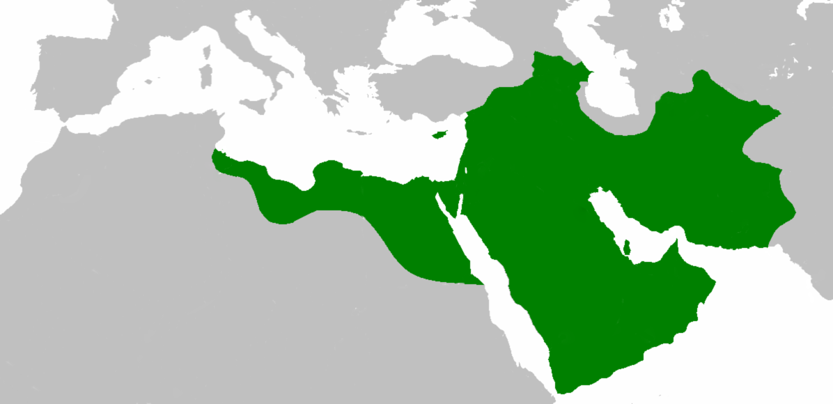
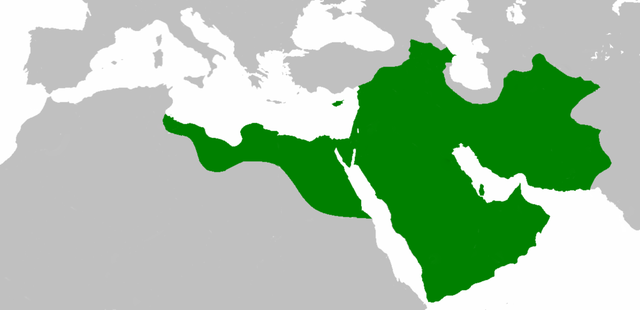
العربية: اتساع الدولة الإسلامية في عهد الخليفة عثمان بن عفان English: Empire of the Rashidun Caliphate at its peak. |
|||
| تریخ | ٢١ جولائی ٢٠٠٧ (original upload date) | |||
| ماخذ | Transferred from en.wikipedia to Commons. | |||
| مصنف | Mohammad adil at سرائیکی ► skr Wikipedia | |||
| Other versions |
|

اجازہ کاری
Mohammad adil from en.wikipedia.org, the copyright holder of this work, hereby publishes it under the following license:
| ایں فائل کوں کریٹو کامنز Attribution 2.5 پولینڈ لائسنس ݙتا ڳیا. Subject to disclaimers. | ||
| لگاؤ: Mohammad adil from en.wikipedia.org | ||
| ||
| This licensing tag was added to this file as part of the GFDL licensing update. |

|
تہاکوں آزاد سافٹ ویئر فاؤنڈیشن ولوں شائع تھئی جی این یو آزاد مسوداتی اجازت نامہ دیاں شرائط استعمال دے تحت ایں دستاویز کوں نقل، تقسیم اتے/ یا ترمیم کرݨ دی اجازت ݙتی ویندی ہے۔ ایں اجازت نامہ دی ہک نقل 'جی این یو آزاد مسوداتی اجازت نامہ دے عنوان نال میسر ہے۔ Subject to disclaimers. |
Original upload log
The original description page was here. All following user names refer to en.wikipedia.
- 2010-04-25 09:06 Cplakidas 1196×580× (50435 bytes) whoops
- 2010-04-25 08:59 Cplakidas 1196×580× (50513 bytes) corrections: Crete, Rhodes, Sicily, Cilicia, W. Armenia & Iberia were raided and invaded, but not permanently occupied until much later. In Africa, the Exarchate of Carthage still controlled most of Tunisia, and no Arabs had yet reached Spain.
- 2009-05-01 06:26 Mohammad adil 1196×580× (46594 bytes) {{GFDL-self-with-disclaimers}}
- 2009-01-26 14:13 Mohammad adil 1196×580× (95308 bytes)
- 2008-03-28 21:12 Mohammad adil 1400×680× (48613 bytes) {{GFDL-self-with-disclaimers}}
- 2008-03-28 21:08 Mohammad adil 1400×680× (48472 bytes) {{GFDL-self-with-disclaimers}}
- 2007-07-21 19:15 Mohammad adil 1400×690× (47455 bytes) {{GFDL-self-with-disclaimers}}
فائل دا تاریخچہ
کہیں خاص ویلے تے تریخ کوں فائل کین٘ویں نظردی ہائی، ݙیکھݨ کیتے اوں ویلے تے کلک کرو۔
| تریخ/ویلہ | تھمب نیل | پاسے | ورتݨ والا | رائے | |
|---|---|---|---|---|---|
| موجودہ | ٠٠:٥٩, ١١ دسمبر ٢٠١٨ | | ١,١٩٦ × ٥٨٠ (٥٨ KB) | عبد الله | Reverted to version as of 19:41, 10 December 2018 (UTC) |
| ٠٠:٥٧, ١١ دسمبر ٢٠١٨ |  | ١,١٩٦ × ٥٨٠ (٥٨ KB) | عبد الله | إزالة خطوط مزعجة | |
| ٠٠:٤١, ١١ دسمبر ٢٠١٨ |  | ١,١٩٦ × ٥٨٠ (٥٨ KB) | عبد الله | إزالة خطوط مضايقة | |
| ٠٩:٢٩, ١٢ دسمبر ٢٠١٧ |  | ١,١٩٦ × ٥٨٠ (٣٧ KB) | Swazzo | Reverted to version as of 23:30, 2 May 2014 (UTC) unnecessary | |
| ١٦:٢٥, ٩ دسمبر ٢٠١٧ |  | ١,١٩٦ × ٥٨٠ (٤٤ KB) | Mehrdad 12 | [[]][[Media:]]]] | |
| ٠٤:٣٠, ٣ مئی ٢٠١٤ |  | ١,١٩٦ × ٥٨٠ (٣٧ KB) | HistoryofIran | Corrected map; regions such as Ghur was not under Rashidun control. | |
| ١٤:٢٧, ١٩ اکتوبر ٢٠١٢ |  | ١,١٩٦ × ٥٨٠ (٤٥ KB) | Cplakidas | correction: the Muslims had not yet established themselves beyond the Caucasus, Derbent and its environs were conquered in the 8th century | |
| ١٣:٥١, ٢٥ جولائی ٢٠١٢ |  | ١,١٩٦ × ٥٨٠ (٤٦ KB) | محک | see also:File:Age of Caliphs.png and:[http://en.wikipedia.org/wiki/Mazandaran#Post_Islamic_history] and:tapuria history book (Ibn Esfandiyar) | |
| ١٤:٠٧, ١٧ جون ٢٠١٢ |  | ١,١٩٦ × ٥٨٠ (٤٩ KB) | OgreBot | (BOT): Reverting to most recent version before archival | |
| ١٤:٠٦, ١٧ جون ٢٠١٢ |  | ١,١٩٦ × ٥٨٠ (٤٩ KB) | OgreBot | (BOT): Uploading old version of file from en.wikipedia; originally uploaded on 2010-04-25 09:06:38 by Cplakidas |
فائل ورتݨ
اِیں فائل نال ہیٹھاں درج ورقہ مربوط ہے:
فائل دا کلجگ ورتاوا
ایہ ٻئے وکی ایں فائل کوں ورتیندن:
- ace.wikipedia.org تے ورتݨ
- af.wikipedia.org تے ورتݨ
- ar.wikipedia.org تے ورتݨ
- عثمان بن عفان
- الخلفاء الراشدون
- زيد بن ثابت
- معركة أجنادين
- الحسن بن علي
- الحسين بن علي
- بلال بن رباح
- سقيفة بني ساعدة
- حروب الردة
- الفسطاط
- خالد بن الوليد
- أبو هريرة
- أبو الأسود الدؤلي
- مارية القبطية
- عمرو بن العاص
- سلمان الفارسي
- أسيد بن حضير
- سعد بن أبي وقاص
- عائشة بنت أبي بكر
- أم حبيبة
- سودة بنت زمعة
- أم سلمة
- الزبير بن العوام
- سعيد بن زيد
- سعد بن عبادة
- عبد الله بن عمر بن الخطاب
- أبان بن سعيد بن العاص
- أبو أيوب الأنصاري
- فتنة مقتل عثمان
- القوقاز
- عبد الله بن الزبير
- أبان بن عثمان بن عفان
- أنس بن مالك
- يزيد بن أبي سفيان
- معركة اليرموك
- معركة ذات الصواري
- طلحة بن عبيد الله
- المغيرة بن شعبة
- عبد الله بن سبأ
- زينب بنت جحش
- زينب بنت خزيمة
- جويرية بنت الحارث
- صفية بنت حيي بن أخطب
- ميمونة بنت الحارث
- أبو سفيان بن حرب
- أبو ذر الغفاري
- عبد الله بن عباس
ایں فائل دا ٻیا جگ ورتݨ ݙیکھو.