فائل:Buyids 970.png

ایں پیشگی ݙکھالے دا حجم:٨٠٠ × ٥٠٩ پکسلز ٻیاں قرارداداں: ٣٢٠ × ٢٠٤ پکسلز | ٦٤٠ × ٤٠٧ پکسلز | ١,٠٢٤ × ٦٥٢ پکسلز | ١,٣٢١ × ٨٤١ پکسلز۔
اصل فائل (١,٣٢١ × ٨٤١ پکسل، فائل دا حجم: ١.٠١ MB، MIME قسم: image/png)
خلاصہ
| تفصیل |
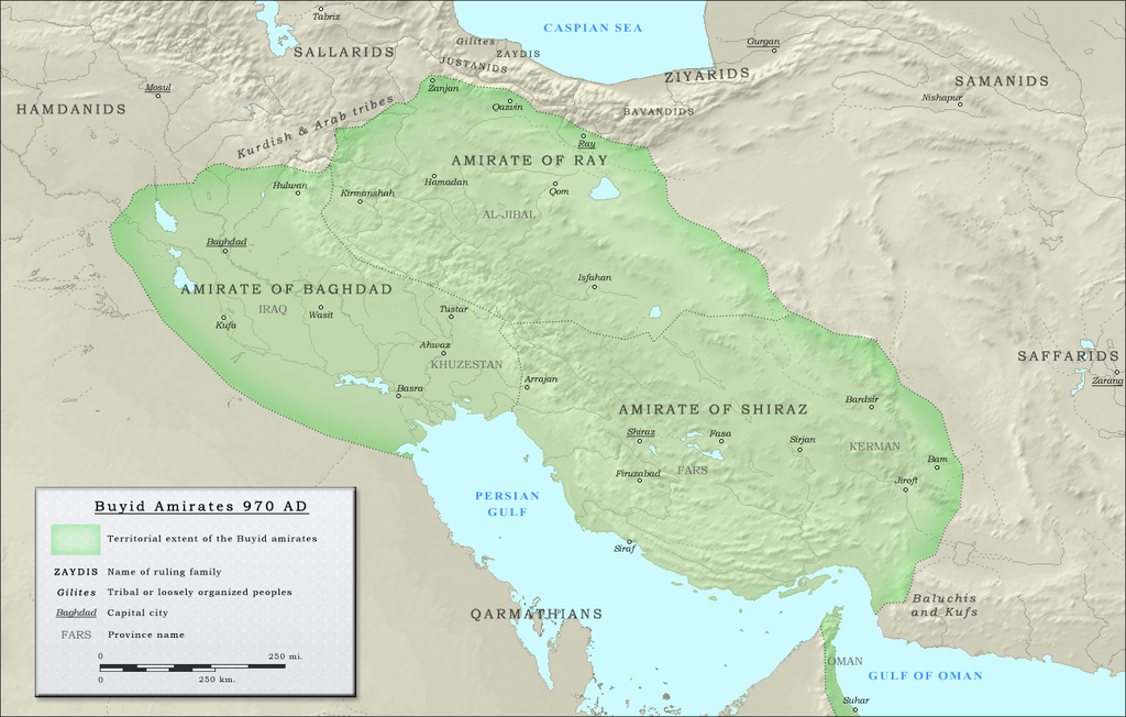
English: Map of the three emirates under control of the Buyid dynasty ca. 970 CE |
| تریخ | |
| ماخذ |
(Original text : Own work. Data sources :
|
| مصنف | ro4444 |
| اجازت (فائل دا دوبارہ استعمال) |
. Original uploader was Ro4444 at en.wikipedia CC-BY-SA-3.0; Released under the GNU Free Documentation License; Released into the public domain (by the author). |
| Other versions | العربيَّة |
اجازہ کاری
| This work has been released into the public domain by its author, Ro4444 at سرائیکی ► skr Wikipedia. This applies worldwide. In some countries this may not be legally possible; if so: Ro4444 grants anyone the right to use this work for any purpose, without any conditions, unless such conditions are required by law. |
Ro4444 at سرائیکی ► skr Wikipedia, the copyright holder of this work, hereby publishes it under the following licenses:
ایں فائل کوں کریٹو کامنز Attribution 2.5 پولینڈ لائسنس ݙتا ڳیا.
لگاؤ: Ro4444 at سرائیکی ► skr Wikipedia
- تساں آزاد ہو
- شیئر کرݨ – کم کوں کاپی نقل کرݨ، ونڈݨ یا کم کوں بھیجݨ کیتے
- وت رلاوݨ – کم کوں فٹ کرݨ
- تلویاں شرائط دے تحت:
- انتساب – جے تبدیلیاں تھیاں ہن تاں تساں مناسب کریڈیٹ ݙیوو، لائسنس کیتے لنک مہیا کرو تے اشارہ ݙیوو۔ تساں کہیں وی مناسب انداز وچ ایہ کر سڳدے ہو، پر ایں طرح ظاہر نہ تھیوے جو لائسنسر تہاکوں یا تہاݙے ورتاوے کوں انتساب کریندا پئے۔
- یکساں شراکت – جے تساں ولدا رَلیندے ہو، تبدیل کریندے ہو یا مواد تے اسریندے ہو تاں تہاکوں اصلی دے طور تے same or compatible license دے تحت آپݨیاں حصہ داریاں ونڈݨیاں پوسن۔

|
تہاکوں آزاد سافٹ ویئر فاؤنڈیشن ولوں شائع تھئی جی این یو آزاد مسوداتی اجازت نامہ دیاں شرائط استعمال دے تحت ایں دستاویز کوں نقل، تقسیم اتے/ یا ترمیم کرݨ دی اجازت ݙتی ویندی ہے۔ ایں اجازت نامہ دی ہک نقل 'جی این یو آزاد مسوداتی اجازت نامہ دے عنوان نال میسر ہے۔ |
تساں آپݨی مرضی دا لائسنس چُݨ سڳدے ہو
Original upload log
The original description page was here. All following user names refer to en.wikipedia.
- 2010-09-27 05:16 Ro4444 1321×841× (1059156 bytes) == Summary == == Description == {{Information |Description= {{en| Political map in English of the Buyids in 970 A.D.}} |Source=Own work. {{clr}} Data sources : * Background map : [[Topographic map#Global 1-kilometer map]] (SRTM3 v.2) (public domain){{clr}
فائل دا تاریخچہ
کہیں خاص ویلے تے تریخ کوں فائل کین٘ویں نظردی ہائی، ݙیکھݨ کیتے اوں ویلے تے کلک کرو۔
| تریخ/ویلہ | تھمب نیل | پاسے | ورتݨ والا | رائے | |
|---|---|---|---|---|---|
| موجودہ | ٢٠:٢٤, ٢٥ جولائی ٢٠١٢ | | ١,٣٢١ × ٨٤١ (١.٠١ MB) | Cplakidas | {{Information |Description={{en|Map of the three emirates under control of the en:Buyid dynasty ca. 970 CE}} |Source=Transferred from [http://en.wikipedia.org en.wikipedia]<br/> (Original text : ''Own work. Data sources : * Background map : [[:en... |
فائل ورتݨ
اِیں فائل نال ہیٹھاں درج ورقہ مربوط ہے:
فائل دا کلجگ ورتاوا
ایہ ٻئے وکی ایں فائل کوں ورتیندن:
- arz.wikipedia.org تے ورتݨ
- ast.wikipedia.org تے ورتݨ
- azb.wikipedia.org تے ورتݨ
- az.wikipedia.org تے ورتݨ
- ba.wikipedia.org تے ورتݨ
- be.wikipedia.org تے ورتݨ
- bg.wikipedia.org تے ورتݨ
- bn.wikipedia.org تے ورتݨ
- ckb.wikipedia.org تے ورتݨ
- de.wikipedia.org تے ورتݨ
- diq.wikipedia.org تے ورتݨ
- el.wikipedia.org تے ورتݨ
- en.wikipedia.org تے ورتݨ
- Ilam province
- Buyid dynasty
- Al-Malik al-Rahim
- Abu Kalijar
- Jalal al-Dawla
- Musharrif al-Dawla
- Sultan al-Dawla
- Baha al-Dawla
- Sharaf al-Dawla
- Samsam al-Dawla
- Izz al-Dawla
- Mu'izz al-Dawla
- Qawam al-Dawla
- Taj al-Dawla
- Diya al-Dawla
- Sama' al-Dawla
- Shams al-Dawla
- Fakhr al-Dawla
- Rukn al-Dawla
- Imad al-Dawla
- Mu'ayyad al-Dawla
- Majd al-Dawla
- 'Adud al-Dawla
- Greater Iran
- History of Shia Islam
- Abu Mansur Fulad Sutun
- Template:Buyid dynasty
- Abu Sa'd Khusrau Shah
- Abu Ishaq Ibrahim (Buyid)
- User:Chickstarr404/Gather lists/4913 – Samarkland by Amin Maalouf
ایں فائل دا ٻیا جگ ورتݨ ݙیکھو.